Storm Antoni - live: Met Office upgrades ‘danger to life’ warnings as flooding sees evacuations
Weather warning in place from 11am to 7pm for south west England and Wales

For free real time breaking news alerts sent straight to your inbox sign up to our breaking news emails
Sign up to our free breaking news emails
The Met Office has upgraded weather warnings to amber as eight people have been evacuated from their flooded Dublin homes.
The first named storm of the year, Storm Antoni moved eastwards in Ireland as heavy rains poured down overnight into this morning.
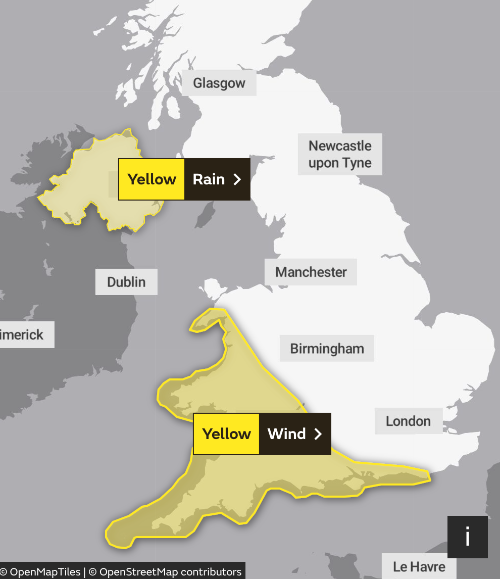
In England and Wales, an amber warning for wind is in place from 11am to 7pm for Devon, Somerset, Dorset and Torbay, and Carmarthenshire, Pembrokeshire and Swansea.
The Met Office warned “flying debris is possible and could lead to injuries or danger to life”.
Two yellow warnings for wind and rain are also in place for large swathes of England, Wales, and Northern Ireland.
Met Office chief meteorologist Steve Willington said: “Storm Antoni will bring some potentially disruptive weather on Saturday as it moves from west to east.
“Northern Ireland is likely to see some of the highest rainfall totals, with 40-60mm falling in some spots, but 20-30 more widely.”
What has the Met Office said about Storm Antoni?
Met Office Chief Meteorologist Steve Willington said: “Storm Antoni will bring some potentially disruptive weather on Saturday as it moves from west to east. Northern Ireland is likely to see some of the highest rainfall totals, with 40-60mm falling in some spots, but 20-30mm more widely. Away from the warning area many will still see a very wet day, especially in north Wales and north England.
“Storm Antoni will also bring strong winds to a swathe of Wales, southwest England and southern coastal areas of England. The strongest winds will affect parts southwest England and southwest Wales where exposed coasts and high ground could see gusts in excess of 60mph. In these areas, gusts inland could reach 50-55mph for a time. These windy conditions will likely coincide with high tides which will present an additional challenge for coastal areas.
“Busy travel networks at this time of year and the possibility of people having made plans to be outside have resulted in the system meeting our criteria for naming, with a strong chance of disruption for those within the warning areas.”
Visit Cornwall issues guidance for campers ahead of Storm Antoni
One Cornwall-based tourist board has issued guidance for campers visiting the area ahead of Storm Antoni’s arrival.
Malcolm Bell, Executive Chair of Visit Cornwall said: “All campers should ask the campsite operator for advice and guidance on their equipment and location, to ensure they are best equipped to cope with the unseasonal gale force winds, and in some exceptional cases such as on very exposed sites that may mean packing away for the duration of the gales.”
When will the UK weather improve?
After a month of largely unsettled weather for the UK, there are some tentative signs of a change, albeit perhaps only briefly, later next week, forecasters said.
Met Office chief meteorologist Steve Willington said: “For the latter half of next week, there are some signals of a shift in the jet stream which may allow for high pressure to build in for southern areas of the UK, increasing the likelihood of some drier weather for a time.
However, at this range, the details are quite uncertain and there’s still a chance of some rain for areas further north. As always, details will become clearer with a shorter lead time.”
When will Storm Antoni hit?
Two weather warnings will be in force on Saturday, with a yellow alert for rain covering most of Northern Ireland from midnight until 11am, where up to 60mm of rain could fall in a single day – comprising nearly three-quarters of Belfast’s average monthly total.
A second warning issued across southwest England and much of Wales will be in place for 12 hours until 8pm, and cautions that strong winds could cause some damage to buildings, with flying debris posing a potentially fatal risk of injuries.
What is behind the recent bad weather?
Britain’s conditions are a stark contrast to Europe, with devastating wildfires recently engulfing parts of Greece and Italy.
The island of Rhodes has seen 19,000 people evacuated, with Greek authorities describing the response as “the largest evacuation from a wildfire in the country.”
These conditions aren’t set to reach the UK though, which is on the northern side of the jet stream, bringing low pressure. The southern side has developed heat over southern Europe.
Last summer, vast swathes experienced high temperatures that exceeded 40C for the first time, with the highest temperature recorded in Coningsby, Lincolnshire on 19 July 2022 at 40.3C.
“Typically we are to the south of that jet stream and what that allows and what it allowed last summer is for a high pressure to build over the UK, and allows the UK to kind of draw up warmer air from the south”, Met Office spokesman Stephen Dixon explained of recent poorer weather conditions earlier this week.
“More air was kind of fed in from the equator almost and moved over the UK and so that high pressure, coupled with the time of year it was, allowed that day on day to rise to the UK to that record level of 40.3C. We just haven’t been in that weather pattern this summer.
“It’s down to that jet stream and how it develops weather towards the UK. At the moment, it’s kind of directed towards the UK, which helps to develop these low pressure systems and gives us a bit of a little autumnal-feel for the weather that we’ve seen in recent weeks.”
Where have the weather warnings been issued?
Rain and wind warnings have been issued for Northern Ireland and parts of south-west Britain respectively.
Northern Ireland will see heavy rain from the early hours of Saturday morning, while parts of Wales and south-west and coastal southern England will be blasted with heavy wind.
Met Office chief meteorologist Steve Willington said the storm will bring “potentially disruptive” weather as it moves from west to east.
He added: “Northern Ireland is likely to see some of the highest rainfall totals, with 40-60mm falling in some spots, but 20-30mm more widely.
“Away from the warning area many will still see a very wet day, especially in north Wales and north England.”
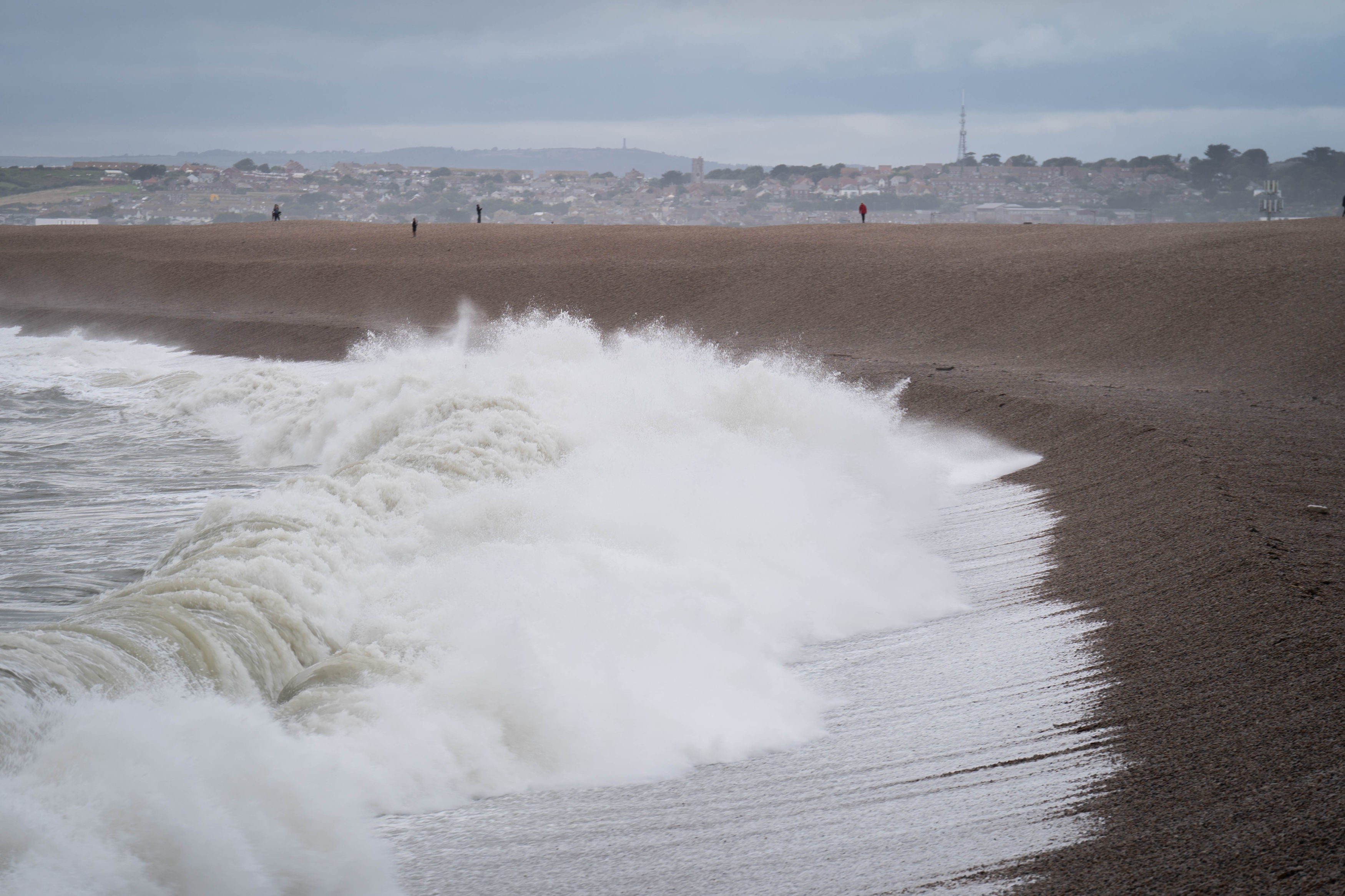
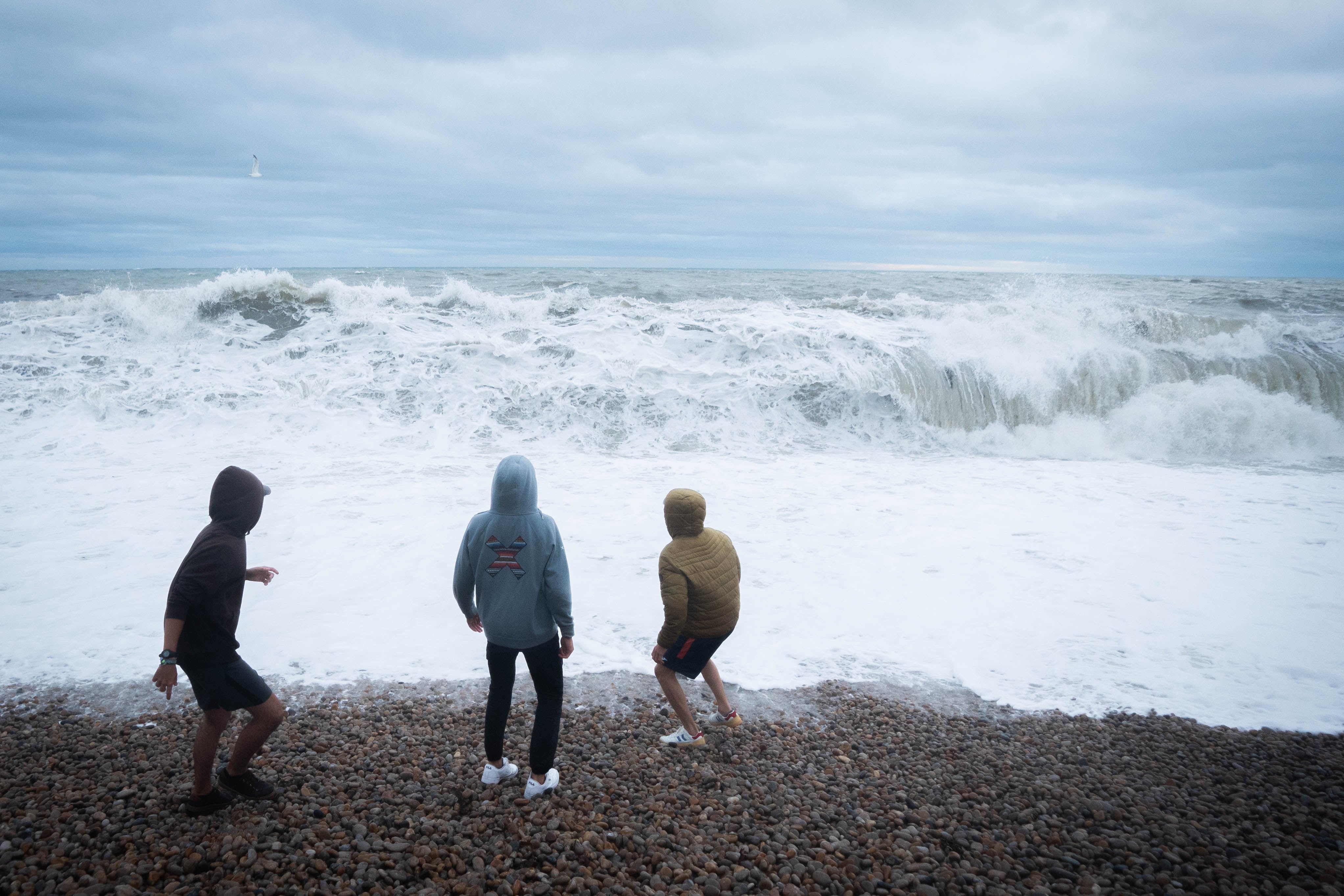
He said that the strongest winds will affect parts of south-west England and south-west Wales, with gusts reaching in excess of 60mph.
“The strongest winds will affect parts south-west England and southwest Wales where exposed coasts and high ground could see gusts in excess of 60mph,” he said.
“In these areas, gusts inland could reach 50-55mph for a time. These windy conditions will likely coincide with high tides which will present an additional challenge for coastal areas.”
RAC issues warning to motorists ahead of Storm Antoni
The RAC’s Rod Dennis warned that Saturday is expected to be the worst day on the roads of the summer so far.
“We expect Saturday to be the worst day on the roads of the summer so far, especially for anyone in the south-west of England - and that’s a lot of people as our research shows it’s the most popular part of the country for leisure trips by car this year,” he said.
“Conditions will be atrocious with a wholly unpleasant mix of very strong winds and locally intense rainfall. The best advice is to slow down significantly to stay safe and avoid exposed moorland and coastal routes until the storm passes.
“Drivers towing caravans and trailers need to be particularly careful in these conditions and those with boxes and bikes on the roof should double-check they’re secured properly.
“Drivers should also watch out for fallen trees and be prepared for the disruption they cause.”
He added that the RAC estimates that around four million cars will be using the roads for leisure journeys across the whole weekend.
Storm Antoni: ‘Danger to life’ warnings as first Met Office-named storm of year to hit UK
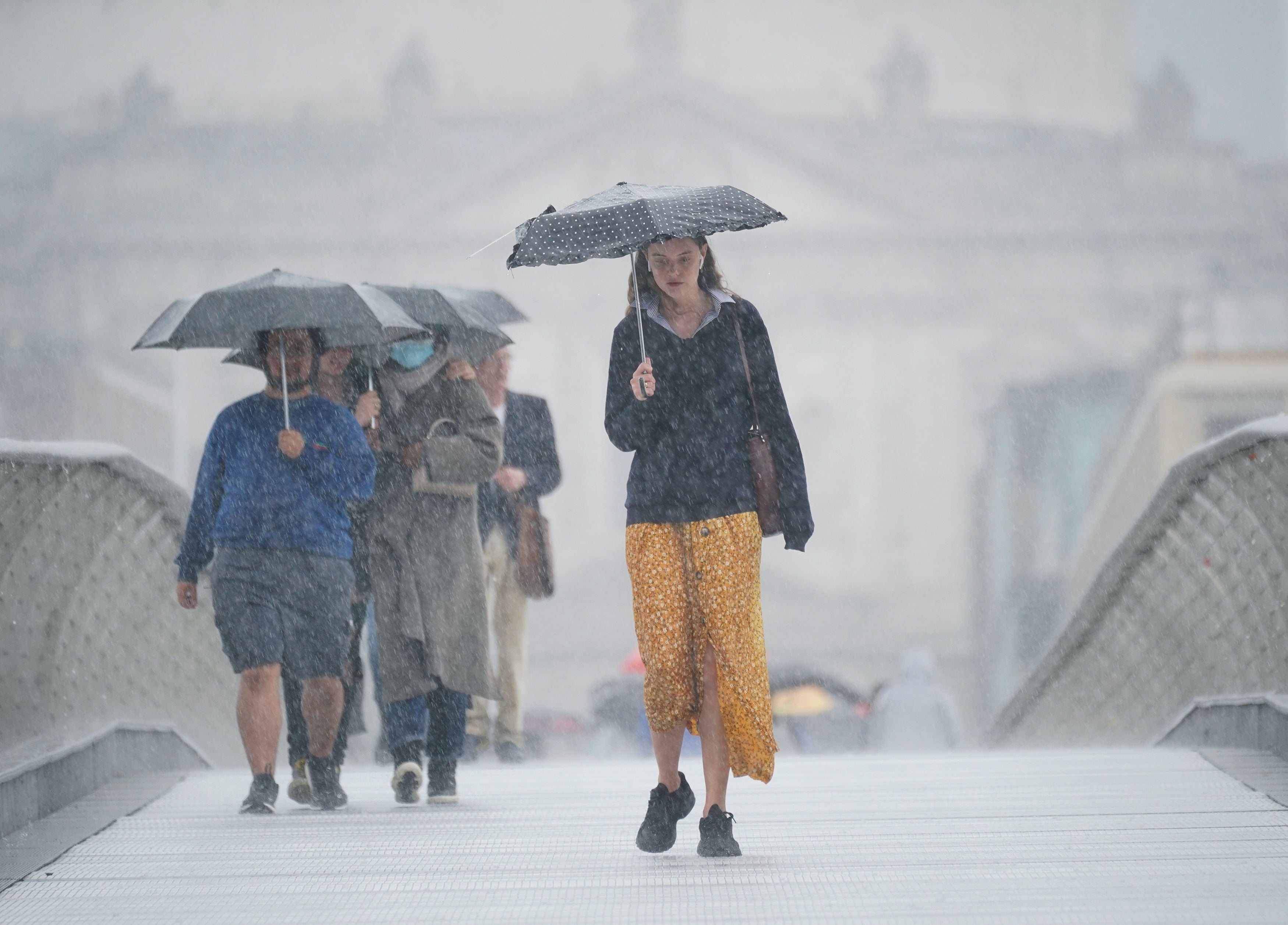
The first Met Office-named storm of the year will hit the UK this weekend with gusts of up to 65mph expected to batter the coastlines and disrupt travel, with heavy rain posing a “danger to life”.
The national forecaster warned that Storm Antoni could also bring winds of up to 50mph inland in parts of south Wales and southwest England, while heavy rains could flood homes and businesses in Northern Ireland.
“Unseasonably” strong winds and fast-flowing rainwaters may disrupt air, rail, road and ferry travel and could bring a “danger to life” as the low-pressure weather system moves in from the Atlantic Ocean, meteorologists said.
Read Andy Gregory’s report here:

‘Danger to life’ warnings as first Met Office-named storm of year to hit UK
Strong winds and rain could cause dangerous flooding, with debris from damaged buildings bringing potentially fatal risk of injurings, forecasters warn
Good afternoon, and welcome to The Independent’s liveblog covering Storm Antoni.
Subscribe to Independent Premium to bookmark this article
Want to bookmark your favourite articles and stories to read or reference later? Start your Independent Premium subscription today.
Join our commenting forum
Join thought-provoking conversations, follow other Independent readers and see their replies
Comments