Your support helps us to tell the story
As your White House correspondent, I ask the tough questions and seek the answers that matter.
Your support enables me to be in the room, pressing for transparency and accountability. Without your contributions, we wouldn't have the resources to challenge those in power.
Your donation makes it possible for us to keep doing this important work, keeping you informed every step of the way to the November election

Andrew Feinberg
White House Correspondent
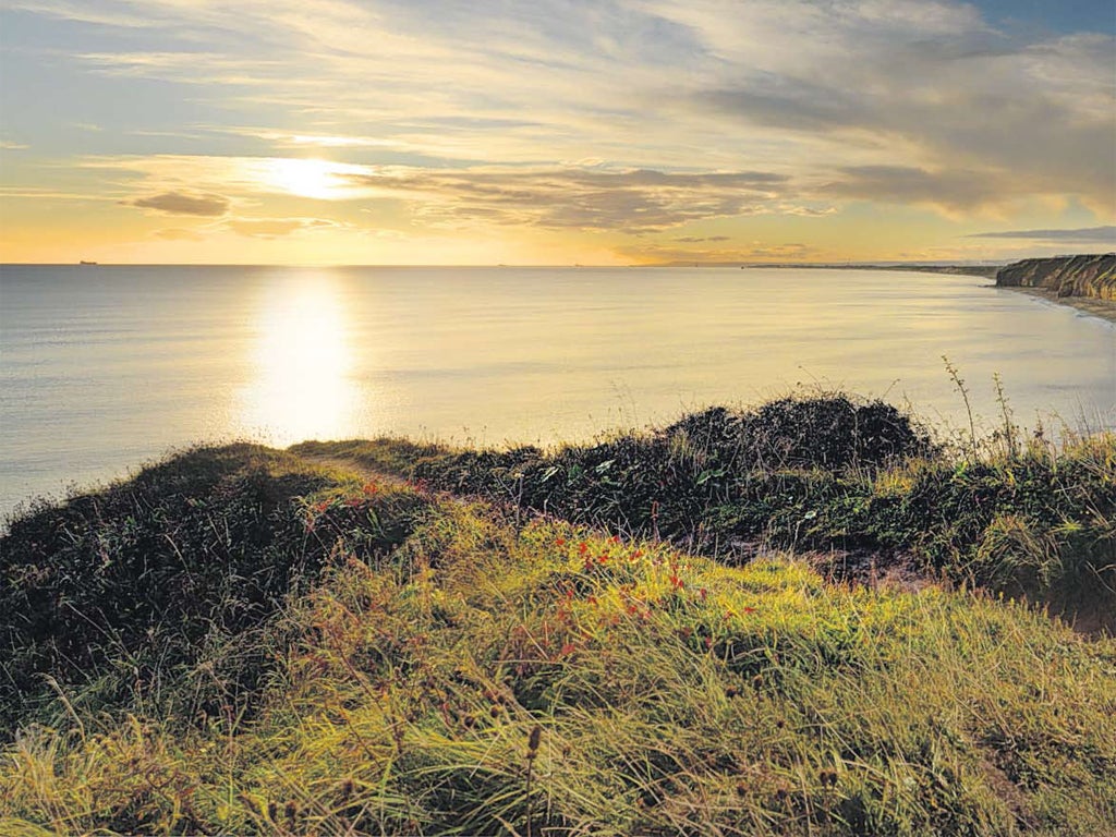
Durham's coastline calls somewhere else to mind. But where? There's a slice of Cornwall here, a bite of South Wales there. It's hard to put your finger on it, but I'm struck by its bewildering prettiness. Coal was once king of this sometimes stark yet drably beautiful post-industrial landscape, and for 150 years coal waste was simply dumped on the beaches, smothering the sand in slag 30ft deep.
The idea that this coastal strip might one day stack up against the best of Britain's coastline might have seemed fanciful a few decades ago, but in the intervening years the sea has washed away the mining waste, while a community regeneration project, Turning the Tide, removed the mechanical detritus and concrete towers, and spruced and scrubbed the beaches. They've transformed the area's superb coastline into a virtue and revealed the charms that made Lord Byron and Lewis Carroll linger here. They've also established a breathtaking coastal route from Seaham to the edge of Hartlepool.
As I begin this walk, I know I'm going to enjoy it, partly because I've just visited Lickety Split, Seaham's brilliant 1950s ice cream parlour. Stepping in the front door is to enter an episode of Happy Days. You could bookend the walk with an ice-cream sundae at the start and finish.
My first landmark is Nose's Point above Blast Beach, named for local furnaces, and once totally blackened by waste. Today, 20 years after the pits closed, it is a burnished brown. Coal is known as black gold, and I'm struck by how these colours dominate the vista. I take a path down to a beach rich with fossils. It's like lingering on another planet but it's no place to lay down a beach towel.
Back on the clifftop, the path skips over a railway and dives into the woodlands of Hawthorn Dene, one of several valleys that cut inland, and underneath a striking railway viaduct. Come here in May and the meadows are awash with wild flowers. "It looks like someone's dropped a huge packet of Smarties," says my companion, Louise Harrington, who was involved in the coastal regeneration. A solitary pit cage remains from the Easington Colliery, while the village looks the classic pit town of tight-terraced houses and roads with functional names, such as First Street.
We climb up steep small valleys and cross a footbridge at Denemouth, the head of the wooded valley of Castle Eden Dene. It's a serene, slightly haunting spot, where the cliffs open up and rivulets nudge here and there on their ambling journey to the North Sea, the valley marshland framed by another spectacular railway viaduct. One final brief ascent takes us high on to the clifftop path and we find ourselves walking over the filled-in shallow topsoil of Blackhall Colliery, monitored by a hovering kestrel.
The neighbouring village of Blackhall Rocks is next, and we finish the walk by threading through a caravan site at Crimdon. On the beach, black-headed gulls and oystercatchers huddle on the sands, and by May the rare little tern will have returned from Africa to nest, all of which are encouraging signs that nature is finally prevailing.
Resolving to return to this vantage point with my family, I ask Louise what she makes of this extraordinary transformation. "The mining is part of our history," she says, "and it's not going away, but we've got a story to tell of wonderful cliffs and denes, and fantastic geology."
More information: thisisdurham.com/outdoors
Mark Rowe stayed at The Rose and Crown (01833 650213; rose-and-crown.co.uk), Teesdale in the Durham Dales, which offers B&B from £75 per person.
Directions
From Seaham, head south past a roundabout to Nose's Point to pick up the footpath. The coastal route is clear enough from north to south, but involves several short detours inland to navigate around the denes or valleys. After the last of these, Blue House Gill, keep close to the coastline, passing a V-stile (grid ref 474384). Follow the cliff contours and walk through several V-stiles and then down and up steps to pass a substation (475382). Pass the caravan site to end at the car park (483373).
Other great Durham trails
Weardale Way
Weardale doesn't have the mammoth flanks of dales further south along the Pennines, but its gently reclining slopes seemed to push the darkening clouds upwards and over the horizon, allowing the fells to drink in the sun all year round.
Running for 77 miles from its headwaters near Killhope to Bede's Cross near Sunderland, via Durham and the county's vale, the Weardale Way as it passes through the Durham Dales is exhilarating for walking. Ephemeral and fractured, the fields are generally good for nothing but grazing sheep and cattle, while withered berries cling to lonely rowans. This is a land where drystone walls don't form neat and tidy frames for chocolate box covers; rather, they simply peter out, as if the men who built them were exhausted by their labours.
Look out for wildlife, which has to be truly hardy to survive: merlin, black grouse, golden plover, curlew and ring ouzel. The Wear and its tributaries wind through small villages, hamlets and remote farms, and along their banks you have a good chance of spotting kingfishers and dippers. Buzzards glide effortlessly above, biding their time as they survey the abundant rabbits.
For more information on the Weardale Way, visit weardaleway.com and thisisdurham.com/outdoors. The Weardale Way is 77 miles long and takes six or seven days to walk. OS Map: North Pennines Teesdale & Weardale OL31
Waterfalls walk
"Listen," grins Simon Wilson, "you can tell there's something coming – just hear that gushing." We turn a corner and come abruptly to a steep-sided drop in front of High Force, one of the UK's largest and highest waterfalls. It's a breathtaking spectacle, with the water of the infant River Tees tumbling over volcanic rock, gathering speed as it heads for the coast.
Wilson, an officer with the North Pennines AONB Partnership, is almost purring. Around us are juniper trees, gorse and heather. We spot black grouse, much rarer than their red cousins, and cobalt nuthatches. Somewhere further up the valley you'll spot red squirrels. "You can get quite spiritual about it all if you're not careful, but it's such a privilege to experience such places of wildness," he says.
We're near the end of our five-mile circular loop that takes in both High Force and its downstream companion Low Force in the heart of Teesdale in the Durham Dales. It's easy walking, and serves as a good prod in the ribcage for anyone who thought Durham started and stopped with the cathedral city. For those who like to sign off a walk with cake, there's good news: the refurbished Bowlees Visitor Centre at the start of this walk opens for business in April.
For further information and route directions, see bit.ly/waterfallswalk
Waskerley Way
If the Pennine Way and its associated footpaths sound a bit daunting (even though many of them aren't) the Waskerley Way is an easygoing level access walk – suitable for wheelchair users – that strikes through another stretch of the county's open moorlands. The paved path follows the line of a disused railway and runs for 10 miles from Consett in the Vale of Durham to Parkhead near Stanhope in Weardale in the Durham Dales. If you get carried away by the glory of it all, the path knits into a more ambitious coast-to-coast walking and cycling route.
It's a remote world of upland sheep farms, viaducts, heather moorland, adders and – something of a surprise – extreme butterflies. According to Dave Liddle, a Durham countryside ranger who is walking with me, when global butterfly experts gather, the stretch of path we are walking near the minuscule hamlet of Waskerley is cited in hushed tones usually reserved for the Amazon or other biodiversity hotspots. The dingy skipper and the dark green fritillary are among several species that thrive on graceful, colourful local plants, such as moonwort and frog orchid and bird's foot trefoil in this northerly outpost. May to late autumn is the time to come for this extraordinary spectacle.
"We're dead lucky in Durham," says Dave. "It's a nature lover's paradise. And where else can you walk for miles and miles and just see nothing but countryside?"
Further information: bit.ly/waskerleyway
Subscribe to Independent Premium to bookmark this article
Want to bookmark your favourite articles and stories to read or reference later? Start your Independent Premium subscription today.
Join our commenting forum
Join thought-provoking conversations, follow other Independent readers and see their replies
Comments