Internet maps 'demolish British history'

Your support helps us to tell the story
From reproductive rights to climate change to Big Tech, The Independent is on the ground when the story is developing. Whether it's investigating the financials of Elon Musk's pro-Trump PAC or producing our latest documentary, 'The A Word', which shines a light on the American women fighting for reproductive rights, we know how important it is to parse out the facts from the messaging.
At such a critical moment in US history, we need reporters on the ground. Your donation allows us to keep sending journalists to speak to both sides of the story.
The Independent is trusted by Americans across the entire political spectrum. And unlike many other quality news outlets, we choose not to lock Americans out of our reporting and analysis with paywalls. We believe quality journalism should be available to everyone, paid for by those who can afford it.
Your support makes all the difference.Internet mapping is wiping the rich geography and history of Britain off the map, Britain's most senior cartographer warned yesterday.
Churches, cathedrals, stately homes, battlefields, ancient woodlands, rivers, eccentric landmarks and many more features which make up the tapestry of the British landscape are not being represented in online maps, which focus on merely providing driving directions, said Mary Spence, President of the British Cartographical Society.
As a result, such monuments could fade from public consciousness, she told a session on the Future of the Map at the annual conference in London of the Royal Geographical Society with the Institute of British Geographers.
"Corporate cartographers are demolishing thousands of years of history, not to mention Britain's geography, at a stroke, by not including them on maps," she said. "We're in danger of losing what makes maps unique; giving us a feel for a place."
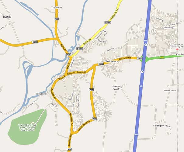
Ms Spence is particularly critical of the maps from the internet giant Google: she accused the company of using poor, inadequate and incorrect data. She compared the Gloucestershire town of Tewkesbury, as shown on Ordnance Survey maps and as shown by Google.
The Ordnance Survey map shows Tewkesbury Abbey; the site of the 1471 Battle of Tewkesbury; the museum; the River Swilgate; various churches; the hospital, council offices, a weir and the cemetery. None are on the Google map. The only feature visible is the Tewkesbury Park Hotel Golf and Country Club.
"There is just a hole where the Abbey is," Ms Spence said. "This is tragic. They call this a map but it is so inadequate. It has not been interpreted in any way. It has no landmarks on it."
Yesterday morning, she said, she had walked to the Royal Geographical Society in Kensington in London along Exhibition Road, home to the Natural History Museum, the Science Museum and the Victoria and Albert Museum; none were shown on the Google map of the area.
There were even worse examples abroad, she said, citing as one of the worst the Google map of the Aral Sea in Central Asia, which is 40 years out of date.
"The public need to know that what they're getting on Google is not accurate and isn't up to date," Ms Spence said.
Ed Parsons, a Google geospatial technologist, accepted the map of the Aral Sea was inaccurate. "We put our hands up to that one," he said. However, he did not accept the company was "wiping features off the map" in Britain – they were hidden but could be accessed. It was possible, he said, to find Tewkesbury Abbey and the Battle of Tewkesbury site by searching Google Maps.
Join our commenting forum
Join thought-provoking conversations, follow other Independent readers and see their replies
13Comments