UK weather live: Commuters suffer delays due to heavy rain and flooding as new Met Office warning issued
The railway line between Swindon and Bristol Parkway is blocked
Your support helps us to tell the story
My recent work focusing on Latino voters in Arizona has shown me how crucial independent journalism is in giving voice to underrepresented communities.
Your support is what allows us to tell these stories, bringing attention to the issues that are often overlooked. Without your contributions, these voices might not be heard.
Every dollar you give helps us continue to shine a light on these critical issues in the run up to the election and beyond

Eric Garcia
Washington Bureau Chief
Rail passengers face delays to their journeys due to flooding this evening as the Met Office issues a fresh weather warning for wind over the weekend.
The railway line between Swindon and Bristol Parkway is blocked, which has resulted in services between London and Bristol and Wales having to be diverted, where possible, said National Rail.
It means passengers are facing delays of up to 30 minutes.
The disruption follows heavy rainfall this week, and comes ahead of a new weather warning from the Met Office with areas of south west England and Wales to be blasted by winds of up to 60mph on Sunday.
The forecaster has issued the yellow weather warning for the region on Sunday from 9am until 11:59pm,
“A yellow warning for wind has been issued for much of Sunday across portions of southwest England and south and west Wales, where gusts could reach or even exceed 60 mph on exposed coasts, and 50-55 mph more widely,” Met Office Deputy Chief Meteorologist Dan Holley said.
The Environment Agency also has 59 flood warnings in place across England, meaning flooding is expected, and 115 flood alerts, meaning flooding is possible.
Environment Agency teams 'on the ground’
With heavy rainfall forecast across many areas of the UK, including some areas already under water, the Environment Agency (EA) has been busy working with impacted communities.
As of 4pm, there were 30 flood warnings in place, where flooding is likely, plus 84 flood alerts, where flooding could happen.
Kate Marks, flood duty manager at the EA, said: “Heavy rainfall across the country means that significant river and surface water flooding impacts are possible in parts of central England today and into Friday. Minor river flooding impacts are also possible in parts of north-east England today and Friday.
“Environment Agency teams continue to be out on the ground, supporting local authorities in responding to surface water flooding.
“People should check their flood risk, sign up for free flood warnings and keep up to date with the latest situation as well as following @EnvAgency on X for the latest flood updates.”
Weather warnings mapped
Here’s a graphic showing the weather warnings in place and the amount of rain expected in each region
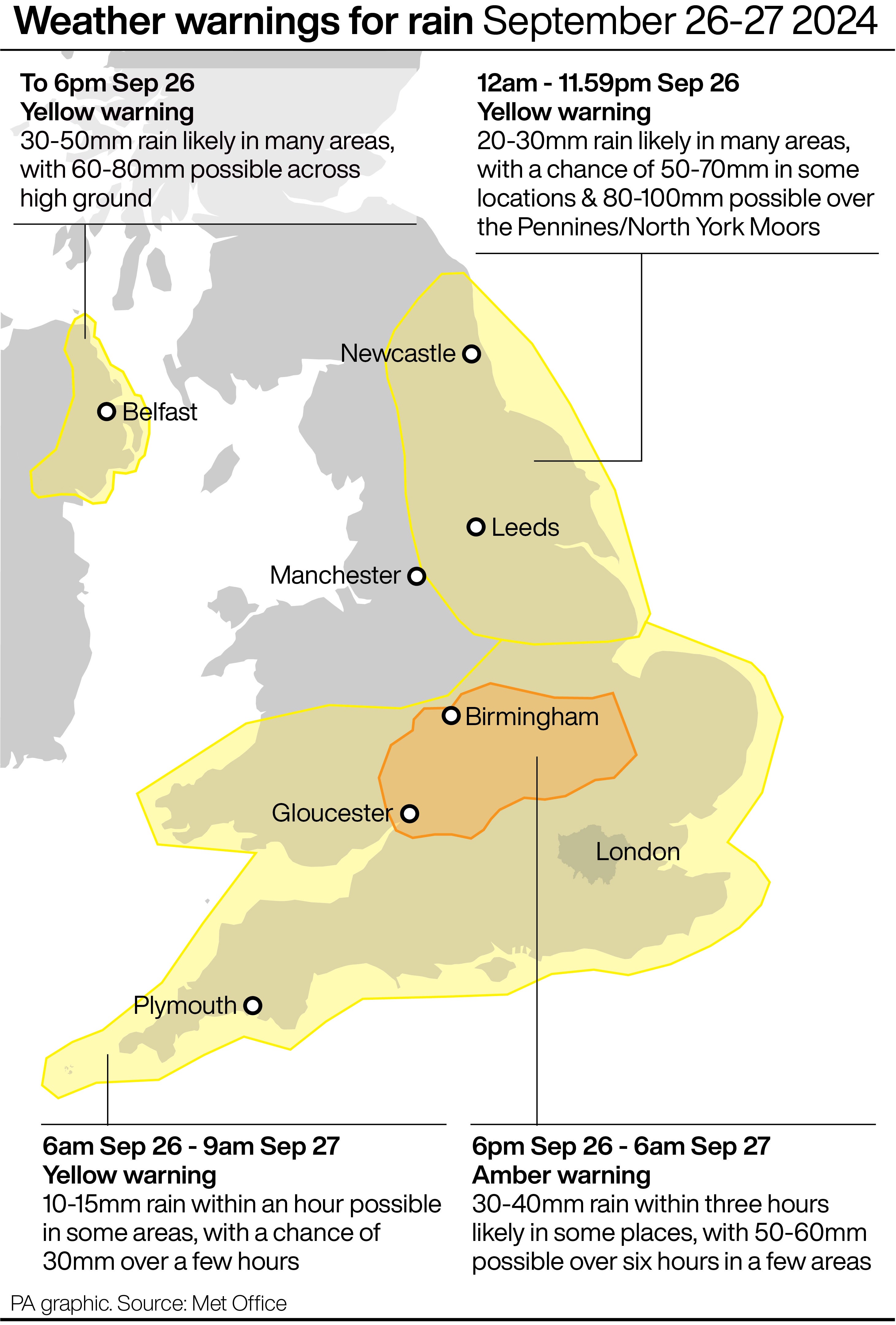
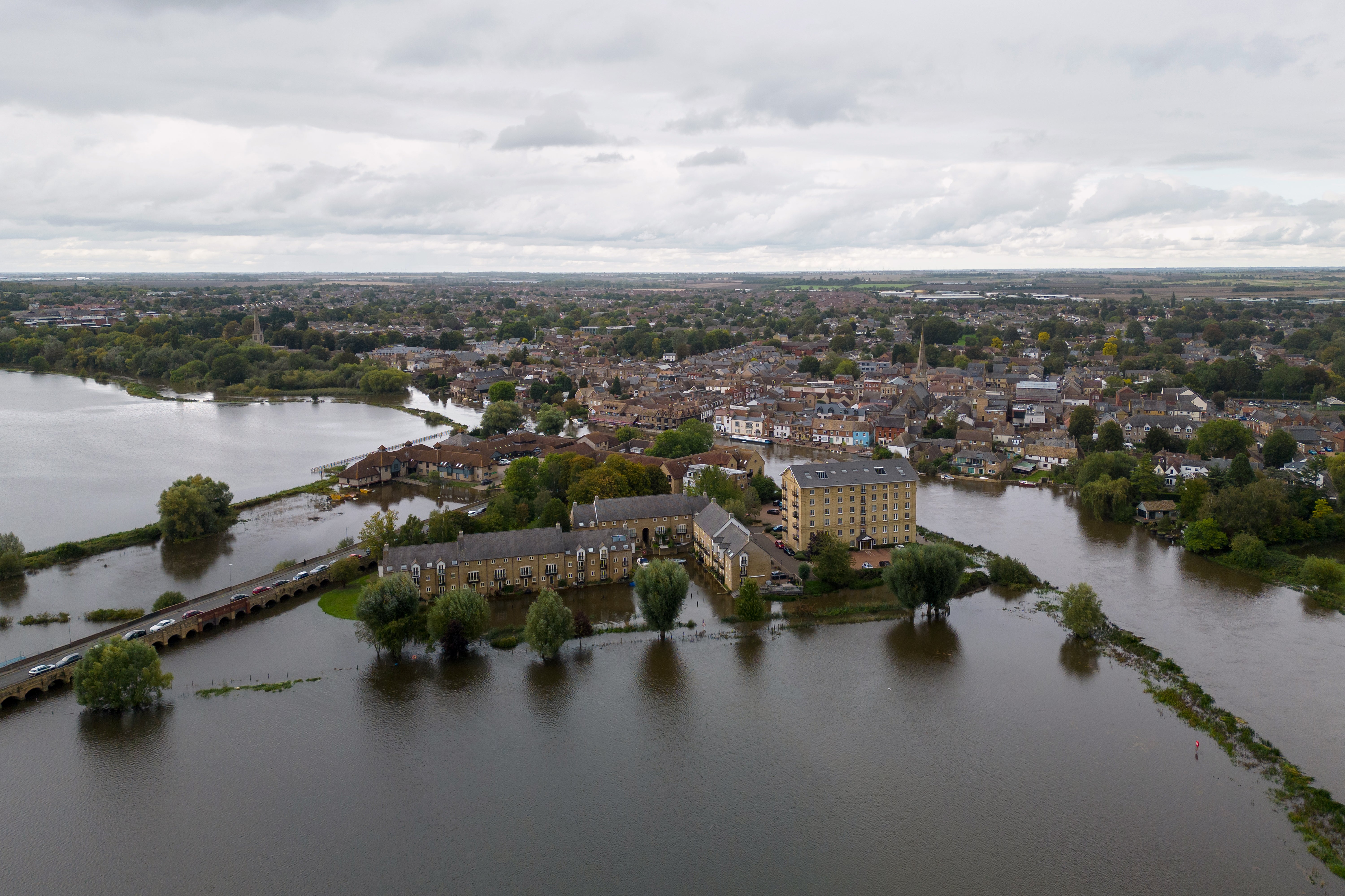
The amber warning is in place for many areas of the country badly impacted by rain earlier this week.
This includes St Ives in Cambridgeshire, where areas are still under water.
Met Office chief meteorologist, Neil Armstrong, said: “he rain will fall onto already saturated ground, potentially affecting communities still recovering from recent flooding.”
What to expect in areas facing yellow and amber warning
As many parts of the country face a blustery and wet night with the chance of disruptions, the Met Office has issued a list of what people should expect under each of the warnings.
For a yellow weather warning:
- There is a slight chance of power cuts and loss of other services to some homes and businesses
- There is a small chance that homes and businesses could be flooded, causing damage to some buildings
- Where flooding occurs, there is a slight chance of delays or cancellations to train and bus services
- Spray and flooding could lead to difficult driving conditions and some road closures
- There is a small chance that some communities will become cut off by flooded roads
- There is a small chance of fast flowing or deep floodwater causing danger to life
For a amber weather warning:
- Spray and flooding probably leading to difficult driving conditions and some road closures
- Homes and businesses are likely to be flooded, causing damage to some buildings
- A good chance some communities will be cut off by flooded roads
- Delays and some cancellations to train and bus services are likely
- Power cuts and loss of other services to some homes and businesses likely
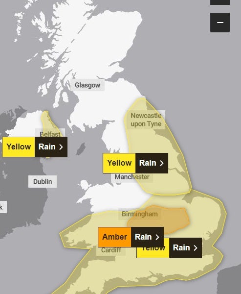
Weather warnings across UK
Here’s the latest map showing the weather warnings in place for rain tonight.
A yellow weather warning for eastern Northern Ireland will end at 6pm, for the north-east at midnight and for the Midlands and the south at 9am.
A more severe amber alert is in place for a central region, and is expected to end at 6pm. The warning states: “Heavy rain is likely to cause flooding and transport disruption this evening and overnight.”
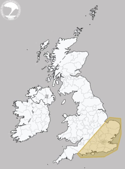
Tornado alert issued
The Tornado and Storm Research Organisation (Toro) is forecasting much of the south-east to see lightning, winds up to 50mph and even “isolated brief tornadoes”.
This includes much of East Anglia, the south-east Midlands and central southern England.
It comes after the Met Office issued an amber warning earlier on Thursday for areas of the Midlands and south of the country, set to come into force at 6pm on Thursday and last for 12 hours.
Looking further ahead
Following Friday, the Met Office says the rain will clear and the country will experience colder conditions.
Met Office deputy chief meteorologist David Oliver said: “The rain will clear south during Friday allowing Arctic air to cross the country.
“This gives a much colder but quieter interlude in the south on Saturday, although a few showers will spread across northern areas. An area of low pressure then moves in from the southwest later in the weekend and crosses the UK during Sunday and Monday.”
Measures of rainfall over next 24 hours
The Met Office has produced a tidy visualisation that shows the amount of rainfall predicted over the next 24 hours.
The north east and central England, where there is an amber alert for rain, face the highest levels.
Amber warning in place until 9am on Friday
Areas affected by the amber warning, including Milton Keynes, Oxfordshire, Cambridgeshire, Leicestershire and the West Midlands, could see 30-40mm of rainfall within three hours, according to the Met Office.
According to the warning, the weather could lead to difficult driving conditions and road closures, homes and businesses are likely to be flooded and there is a “good chance” some communities will be cut off due to floods.
Delays and cancellations to train and bus services and power cuts are also likely.
Subscribe to Independent Premium to bookmark this article
Want to bookmark your favourite articles and stories to read or reference later? Start your Independent Premium subscription today.
Join our commenting forum
Join thought-provoking conversations, follow other Independent readers and see their replies
Comments