UK weather live: Tornado alert issued as heavy rain and thunderstorms strike amid Met Office warnings
The Tornado and Storm Research Organisation has forecast much of the south-east to see lightning and winds up to 50mph
Your support helps us to tell the story
My recent work focusing on Latino voters in Arizona has shown me how crucial independent journalism is in giving voice to underrepresented communities.
Your support is what allows us to tell these stories, bringing attention to the issues that are often overlooked. Without your contributions, these voices might not be heard.
Every dollar you give helps us continue to shine a light on these critical issues in the run up to the election and beyond

Eric Garcia
Washington Bureau Chief
Warnings of flooding and even brief tornadoes have been issued for parts of the UK as heavy rain begins to lash down on many regions of the country.
The Met Office a more severe amber alert is also active for a central region of England - including Birmingham, Worcester, Leicester and Peterborough - with rain likely to cause flooding and disruption this evening and Friday morning.
The Tornado and Storm Research Organisation has also forecast much of the south-east will see lightning, winds up to 50mph and even “isolated brief tornadoes”. This includes much of East Anglia, the south-east Midlands and central southern England.
More than 50 flood warnings have been issued by the Environment Agency across England, meaning flooding is expected, and 200 flood alerts, meaning flooding is possible.
It follows heavy rain and flash flooding in some parts of the country on Monday and Tuesday. In Northamptonshire, a holiday park was evacuated due to flooding on Tuesday night.
Met Office chief meteorologist Neil Armstrong said: “We are expecting an area of slow-moving showers and thunderstorms to develop this afternoon and evening across parts of the Midlands. The rain will fall onto already saturated ground, potentially affecting communities still recovering from recent flooding.”
Check your journeys before you travel - Network Rail
Network Rail, which manages stations and railway lines across the country, has issued a warning to passengers who will be catching services in the morning.
Following the wet weather tonight in many areas of the country, the group warns rain can slow down journeys, causing disruptions for users.
More than 50 flood warnings in place as UK deluged by rain and high winds
As of 11.20pm, the Environment Agency had 51 flood warnings in place across England, meaning flooding is expected, and 120 flood alerts, meaning flooding is possible.
Areas of Bedfordshire, Northamptonshire and Oxfordshire are listed as being the most vulnerable.
The Met Office said: “Slow moving showers and thunderstorms will develop through the afternoon, merging into a large band of heavy rain through the evening, before clearing slowly south overnight.
“Some places, especially across central and eastern parts of the warning area, are likely to receive 30-40mm in three hours or less, and perhaps 50-60mm or more in around six hours.
“This rain will fall onto already saturated ground and affect communities recovering from recent flooding. Travel disruption and further flooding is likely, with rivers continuing to rise after the rain clears.”
‘Anyone for waterpolo?’ Telford FC call for volunteers as stadium flooded
What the weather will be like at the weekend
Looking past the wet weather tonight and on Friday, the Met Office is forecasting a chilly Saturday before more wet weather on Sunday.
Met Office deputy chief neteorologist David Oliver said: “The rain will clear south during Friday allowing Arctic air to cross the country. This gives a much colder but quieter interlude in the south on Saturday, although a few showers will spread across northern areas.
“An area of low pressure then moves in from the southwest later in the weekend and crosses the UK during Sunday and Monday.
“Although there is still some uncertainty about the exact behaviour of this system and therefore where may see any impacts, it will bring the potential for some wet and windy weather late on Sunday and into the start of next week. Stay up to date with the latest forecast for your area.”
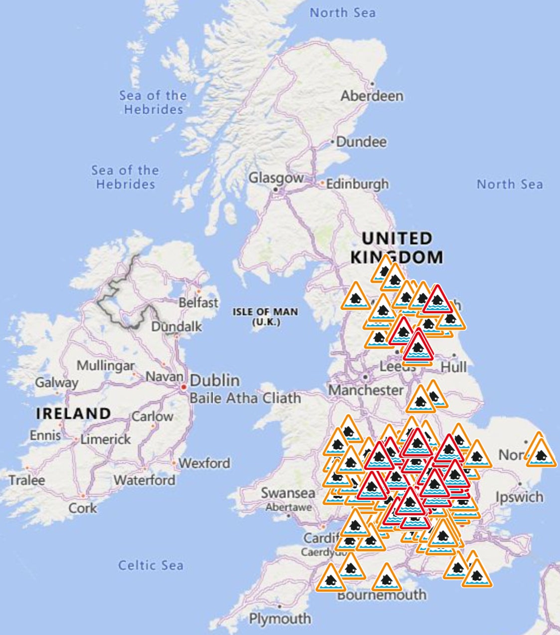
Mapped: 44 red and yellow flood alerts issued in England
Alternative means of travel
While the rain comes down in many areas of the country, we look back here at a picture taken today on the River Cam in Cambridge where passengers on a boat protect themselves from the downpours.
Cambridge is under an amber alert tonight, which means flooding is likely.

More flood warnings issued across England
As of 8.46pm, the Environment Agency had 40 flood warnings in place across England, meaning flooding is expected, and 114 flood alerts, meaning flooding is possible.
Areas of Bedfordshire, Northamptonshire and Oxfordshire are listed as being the most vulnerable.
The Tornado and Storm Research Organisation (Toro) is also forecasting that much of the South East could see lightning, winds up to 50mph and even “isolated brief tornadoes”.
Important people adjust their driving behaviour and take extra care - National Highways
With yellow and amber warnings for much of England warning of disruption on the roads, National Highways has urged caution from drivers.
National network manager Stephen Basterfield said: “With heavy rain expected to cause further flooding and disruption today and overnight its important people adjust their driving behaviour and take extra care.
“Road users should plan their journey and check the latest updates on diversion routes before they travel as these could be impacted with more rainfall.
“We have a section of our website dedicated to travelling when it is raining, as part of our guide to travelling in severe weather.”
Subscribe to Independent Premium to bookmark this article
Want to bookmark your favourite articles and stories to read or reference later? Start your Independent Premium subscription today.
Join our commenting forum
Join thought-provoking conversations, follow other Independent readers and see their replies
Comments