A savage force of nature – and mounting evidence they are becoming more violent

Your support helps us to tell the story
From reproductive rights to climate change to Big Tech, The Independent is on the ground when the story is developing. Whether it's investigating the financials of Elon Musk's pro-Trump PAC or producing our latest documentary, 'The A Word', which shines a light on the American women fighting for reproductive rights, we know how important it is to parse out the facts from the messaging.
At such a critical moment in US history, we need reporters on the ground. Your donation allows us to keep sending journalists to speak to both sides of the story.
The Independent is trusted by Americans across the entire political spectrum. And unlike many other quality news outlets, we choose not to lock Americans out of our reporting and analysis with paywalls. We believe quality journalism should be available to everyone, paid for by those who can afford it.
Your support makes all the difference.Hurricanes are one of the most destructively powerful forces of nature and their existence depends on the surface temperature of the ocean reaching at least 26C. One obvious question is whether Gustav is the result of rising sea temperatures associated with global warming.
The simple answer is that it is virtually impossible to link any one weather event with climate change, yet there is mounting evidence that global warming could be causing hurricanes to increase in both frequency and intensity.
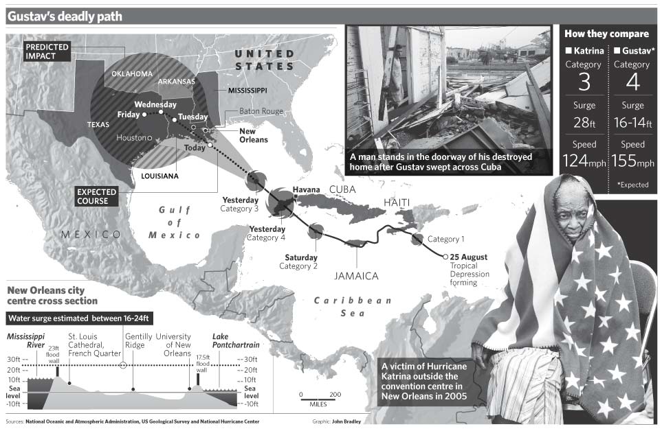
Ray Nagin, the Mayor of New Orleans, said yesterday that the temperature of the sea surface in parts of the Gulf of Mexico was 90F (32.2C). This means that as Gustav crosses the Gulf to the US coast today it is likely to become much stronger than the Category 3 it was for most of yesterday. Scientists have warned Mr Nagin that Gustav could easily reach Category 5 status – the highest on the Saffir-Simpson scale – by the time the hurricane makes its expected landfall to the west of New Orleans today.
Hurricanes in this region at this time of the year are not unusual. They form when the sea warms up during the summer.
All hurricanes begin life as a cluster of thunderstorms which gather to form columns of warm, moist air that rise above the sea. When these thunderstorms become concentrated they create pillars of humid air extending from the sea surface to the boundary of the atmosphere. At the base of the pillar, low pressure sucks in more air and moisture. Meanwhile, air at the top of the pillar cools rapidly, falling into a central well that becomes the "eye" of the storm as the structure begins to spin under the influence of the Earth's rotation.
The point about tropical cyclones is that they possess immense amounts of energy which is taken in as heat and humidity from the ocean and released again as the moisture condenses and cools. As a hurricane begins to move across a warm ocean it can gather more energy, which is dissipated as soon as it hits land.
The energy of a hurricane is unleashed in two ways. One is high wind speeds – more than 155mph in a Category 5 hurricane – and the other is the high waves caused by a storm surge – a result of the low pressure that forms over the sea beneath the storm.
There is little doubt now that hurricanes in the North Atlantic have become more frequent over the past few decades. Although the past two years have been normal, 2005, the year of hurricane Katrina, was the most active on record, with 27 named storms, 15 of them big enough to be classified as hurricanes. Of these, seven were Category 3 or higher on the five-point scale – five more major hurricanes than in a typical Atlantic season. Indeed, Hurricane Wilma in October 2005 became the strongest Atlantic storm ever recorded, breaking the previous record set in 1988. So far, 2008 has been relatively active. There have been seven named storms, including three hurricanes. This time last year there had been five named storms and one was a hurricane.
Because of the generally chaotic nature of hurricanes, it was once generally thought that their frequency or intensity had little to do with climate change. Differences in annual activity were more likely to be caused by local conditions – the weather, in other words, rather than climate.
Although it may be common sense to suggest that rising sea temperatures are likely to trigger more hurricanes, and make them more intense, it is by no means obvious. A warmer atmosphere, for instance, may make hurricanes less intense by diminishing the temperature difference with the sea, and higher temperatures may also create winds, scattering tropical storms and making hurricanes less frequent.
However, a study in 2005 by Kerry Emanuel of the Massachusetts Institute of Technology began to change this view, suggesting a link between hurricane activity and rises in ocean temperature caused by global warming and climate change. And in 2007, a study by the US National Centre for Atmospheric Research in Boulder, Colorado, found a link between the record number of tropical storms in the North Atlantic over the past decade to rising temperatures and global warming.
The analysis looked at records of storms going back a century and found no other way of explaining the significant increase seen in more recent years. "We are led to the confident conclusion that the recent upsurge in tropical cyclone frequency is due in part to greenhouse warming, and this is most likely the dominant effect," the scientists said.
Join our commenting forum
Join thought-provoking conversations, follow other Independent readers and see their replies
Comments